|
Soldier4Christ
|
 |
« Reply #75 on: April 06, 2006, 09:24:26 PM » |
|
103. Gregor Schwinghammer
Gregor Schwinghammer claims he saw the Ark from an F-100 aircraft in the late 1950s, while assigned to the 428th Tactical Flight Squadron based in Adana, Turkey. Schwinghammer said it looked like an enormous boxcar lying in a gully high up on Mount Ararat. He said U-2 pilots had photographed it.
Note: Many others claim to have seen the Ark. Some stories are of questionable validity, and others are inconsistent with many known details. Only the most credible are summarized above.
Many of the Earths Previously Unexplained Features Can Be Explained by a Cataclysmic Flood.
The origin of each of the following is a subject of controversy within the earth sciences. Each has many aspects inconsistent with standard explanations. Yet all appear to be consequences of a sudden and unrepeatable eventa cataclysmic flood whose waters erupted from interconnected, worldwide subterranean chambers with an energy release exceeding the explosion of 10 billion hydrogen bombs. Consequences of this event included the rapid formation of the features listed below. The mechanisms involved are well-understood.
Part II: Fountains of the Great Deep
If a culture ignored, for any reason, an event as cataclysmic as a global flood, major errors or misunderstandings would creep into science and society. One of the first would be the explanation for fossils. Typically, Fossil A lies below Fossil B, which lies below Fossil C, etc. If flood explanations were weak or disallowed, then evolution would provide an answer: Organism A turned into B which later turned into C. Fossil layers would represent vast amounts of time. Other geologic features could then be easily fit into that time frame. With so much time available, possible explanations multiplyexplanations not easily tested in less than a million years. A century after Darwin, evolutionary explanations would be given for the universe, chemical elements, heavenly bodies, earth, and life. Part I of this book shows that these ideas are false.
Part II will show, in ways an interested layman can understand, the flaws in these geologic explanations and that a global flood, with vast and unique consequences, did occur. For example, coal, oil, and methane did not form over hundreds of millions of years; they formed in months. Fossils and layered strata did not form over a billion years; they formed in months. The Grand Canyon did not form in millions of years; it formed in weeks. Earths major mountains did not form over hundreds of millions of years; each formed in hours. These statements may appear shocking, until one has examined the evidence in Part II. If you feel there must be experts who can refute this scientific evidence, then see pages 344346. You will be hard-pressed to find anyone willing to accept that sincere and fair debate offera standing offer since 1980.
Ironically, some leading creationists who believe in a global flood have contributed to its frequent rejection by advocating unsound mechanisms for the flood. They have failed to clearly answer peoples most basic questions: Where did so much water come from, and where did it go?
One such explanation is the canopy theory. (Pages 306314 examine its many problems.) Others, who know these problems, have proposed an equally weak explanation called catastrophic plate tectonics. Basically, it is the flawed plate tectonic theory speeded up a millionfold by unworkable mechanisms and assumed miracles. Unfortunately, authors of these flood explanations have declined to compare and publish joint critiques of our respective theories.
Past failure to answer honest flood questions opened the door to evolution and old-earth beliefs. Answering those questions will begin to (1) reestablish the flood as earths defining geological event, and (2) reverse serious errors that have crept into science and society. Dont be surprised at how catastrophic the flood was. Just follow the evidence.
|
|
|
|
|
 Logged
|
Joh 9:4 I must work the works of him that sent me, while it is day: the night cometh, when no man can work.
|
|
|
|
Soldier4Christ
|
|
« Reply #76 on: April 06, 2006, 09:27:00 PM » |
|
(Figure 41 purposefully left out)
Figure 41: Grand Canyon. The Grand Canyon, awesome and inspiring when viewed from its rim, is even more so from the air. From above, new insights become obvious. For example, have you ever wondered how the Grand Canyon formed? The standard answer for over a century has been that primarily the Colorado River and side streams carved out the Grand Canyon over millions of years. If that happened, wouldnt you expect to find a gigantic river delta where the Colorado River enters the Gulf of California? Its not there. Nor can geologists find it anywhere else. Where did all the dirt1,000 cubic miles of itgo?
If you look carefully near the center of the picture, you will see four segments of this river. Compare the thin river with the canyons vast expanse. Is it possible for that rivers relatively small amount of water to carve such a huge canyonone of the seven wonders of the natural world? If so, why did it not happen on dozens of faster and larger rivers? How could side streams have cut the many large side canyons without a large, steady water source? After studying far broader issues in this section, you will see a gigantic water source and a surprisingly simple, but complete, explanation for the Grand Canyons rapid formation and where the dirt went.
The Hydroplate Theory: An Overview
New evidence shows that the earth has experienced a devastating, worldwide flood, whose waters violently burst forth from under the earths crust. Standard textbook explanations for many of earths major features are scientifically flawed. We can now explain, using well-understood phenomena, how this cataclysmic event rapidly formed so many features. These and other mysteries, listed below, are best explained by an earthshaking event, far more catastrophic than almost anyone has imagined.
* The Grand Canyon and Other Canyons
* Mid-Oceanic Ridge
* Continental Shelves and Slopes
* Ocean Trenches (pages 136155)
* Earthquakes
* Magnetic Variations on the Ocean Floor
* Submarine Canyons
* Coal and Oil Formations
* Methane Hydrates
* Ice Age
* Frozen Mammoths (pages 178205)
* Major Mountain Ranges
* Overthrusts
* Volcanoes and Lava
* Geothermal Heat
* Strata and Layered Fossils (pages 158168)
* Limestone (pages 170175)
* Metamorphic Rock
* Plateaus
* Salt Domes
* Jigsaw Fit of the Continents
* Changing Axis Tilt
* Comets (pages 208237)
* Asteroids and Meteoroids (pages 240255)
Each appears to be a consequence of a sudden and unrepeatable eventa global flood whose waters erupted from interconnected, worldwide subterranean chambers with an energy release exceeding the explosion of 30 trillion hydrogen bombs. When the hydroplate theory is explained later in this chapter, it will resolve the parade of mysteries described in the next few pages. A subsequent chapter is devoted to each topic highlighted in blue. All 24 topics could be expanded into separate chapters.
But first, what is a hydroplate? Before the global flood, considerable water was under earths crust. Pressure increases in this subterranean water ruptured that crust, breaking it into plates. The escaping water flooded the earth and allowed continents and preflood mountains to sink. Because hydro means water, those crustal plates will be called hydroplates. Where they broke, how they moved, and hundreds of other details and evidenceall consistent with the laws of physicsconstitute the hydroplate theory and explain to a great extent why the earth looks as it does.
|
|
|
|
|
Logged
|
Joh 9:4 I must work the works of him that sent me, while it is day: the night cometh, when no man can work.
|
|
|
|
Soldier4Christ
|
|
« Reply #77 on: April 07, 2006, 06:18:52 AM » |
|
A Few of the Mysteries The Grand Canyon and Other Canyons. See Figure 41. Mid-Oceanic Ridge. One of our planets most dramatic features, the Mid-Oceanic Ridge, was discovered in the 1950s. It wraps around the earth and is the worlds longest mountain range46,000 miles. [See Figure 42 on page 103.] Unlike most mountains, it is composed of a type of rock called basalt. Because most of the ridge lies on the ocean floor, relatively few people know it exists. How did it get there? Why is it primarily on the ocean floor? Why does it intersect itself in a Y-shaped junction in the Indian Ocean? The portion in the Atlantic Ocean is called the Mid-Atlantic Ridge. Is it just a coincidence that it splits the Atlantic from north to south and is perpendicular to and bisected by the equator? If Europe, Africa, and the Americas were once connected, how did they break apart? 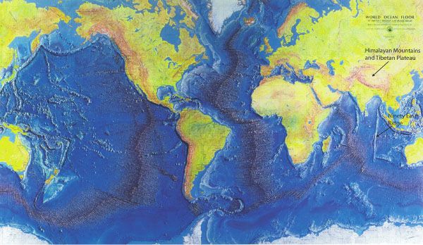 Figure 42: World Ocean Floor. Notice the characteristic margins of each continent. Seaward from each ocean beach is a shallow, gradually sloping continental shelf, then a relatively steep drop, called the continental slope. This strange pattern is worldwide. Why? For a better look at the typical shape of this margin, see Figure 45 on page 103. Also notice the different characteristics of (1) the continents and ocean basins, and (2) the Atlantic and Pacific basins. Ninety East Ridge is so named because it lies almost exactly along 90ºE longitude. Its straightness, 3,000-mile length, and curious north-south orientation aimed at the Himalayas are important clues to past events on earth. (Note: As one moves toward polar regions on this type of map projection, east-west distances are stretched and do not reflect true distances.) 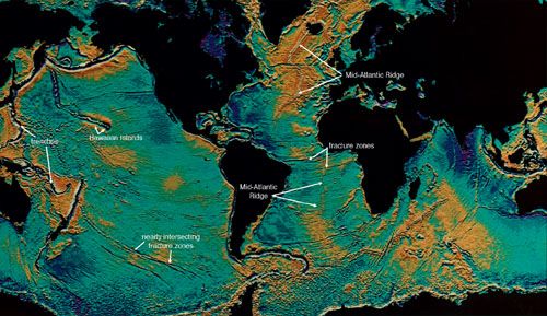 Figure 43: Unlevel Sea Level. An amazing technological development reveals details on the ocean floor. The U.S. Navys SEASAT satellite measured with a radar altimeter the satellites distance above the oceans surface with an accuracy of several inches! Sea level is far from level. Instead, the oceans surface humps up over mountains on the ocean floor and depresses over trenches. The gravitational attraction of the Hawaiian Islands, for example, pulls the surrounding water toward it. This raises sea level there about 80 feet higher than it would be otherwise. The satellites data have been color coded to make this spectacular picture of the oceans surface. Darker areas show depressions in sea level. Notice that the ocean surface is depressed over long scars, called fracture zones, running generally perpendicular to the Mid-Oceanic Ridge. Which theory explains this: the plate tectonic theory or the hydroplate theory? Also consider the nearly intersecting fracture zones in the South Pacific. Which theory explains them? |
|
|
|
|
Logged
|
Joh 9:4 I must work the works of him that sent me, while it is day: the night cometh, when no man can work.
|
|
|
|
Soldier4Christ
|
|
« Reply #78 on: April 07, 2006, 06:22:42 AM » |
|
Plate tectonics, currently the most popular theory in earth science, offers unsatisfactory answers to these and other questions. According to this theory, earths crust is composed of a dozen or so plates,1 each 3060 miles thick. They move with respect to each other, about an inch per yearthe rate a fingernail grows. Continents and oceans ride on top of these plates. Sometimes a continent, such as North America, is on more than one plate. For example, different parts of North America, separated by the San Andreas Fault running up through California, are sliding past each other. Supposedly, material deep inside the earth is rising toward the crest of the entire Mid-Oceanic Ridge. Once it reaches the crest, it moves laterally away from the ridge. This claimed motion is similar to that of a conveyor belt rising from under a floor and then moving horizontally along the floor. However, many little-known problems, discussed below, accompany plate tectonics. Cutting across the Mid-Oceanic Ridge at almost right angles are hundreds of long cracks, called fracture zones. Whenever the axis of the Mid-Oceanic Ridge is offset, it is always along a fracture zone. [See Figure 43 on page 103.] Why? According to plate tectonics, plates move parallel to fracture zones. But fracture zones are not always parallel. Sometimes they are many degrees out of parallel.2 Several fracture zones practically intersect! How then can solid plates be bounded by and move in the direction of these fracture zones? Can a train move on tracks that arent parallel? Notice the white arrows in Figure 43 showing nearly intersecting fracture zones. In many places on the Atlantic and Pacific floors, segments of the Mid-Oceanic Ridge overlap for about 10 miles. These are called overlapping spreading centers.3 [See Figure 44.] If plates are moving away from the Mid-Oceanic Ridge, then the distance between overlapping segments must be increasing. However, overlapping regions are always near each other. Three of the most perplexing questions in the earth sciences today are barely verbalized in classrooms and textbooks: What force moves plates over the globe? By what mechanism? What is the energy source? The hydroplate theory gives a surprisingly simple answer. It involves gravity, the Mid-Atlantic Ridge, and waterlots of it. 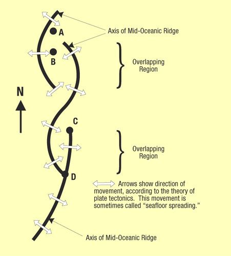 Figure 44: Overlapping Spreading Centers. Bold lines represent the axes of the Mid-Oceanic Ridge. According to plate tectonics, the ocean floor is moving in the direction of the hollow arrowsaway from the Mid-Oceanic Ridge. If so, in which direction is point B moving? If B is stationary, and A is moving east, why is there no fault between them? What could possibly be happening at C and D if the plate tectonic theory is correct? Continental Shelves and Slopes. Why do the edges of all continents have such distinctive and similar slopes? [See Figures 42 and 45.]  Figure 45: Continental Margin. The typical shape of ocean-continent boundaries is shown here. The actual continental boundary is generally considered to be halfway down the continental slope. Compare this figure with Figure 42 on page 103, and notice that Asia and North America would become connected by a wide land bridge if sea level were lowered about 300 feet. Australia and Asia would be almost connected. Sediments and sedimentary rock are shown in yellow. |
|
|
|
|
Logged
|
Joh 9:4 I must work the works of him that sent me, while it is day: the night cometh, when no man can work.
|
|
|
|
Soldier4Christ
|
|
« Reply #79 on: April 07, 2006, 06:23:07 AM » |
|
Ocean Trenches. Ocean trenches are long, narrow depressions on the ocean floor, some of which are several times deeper than the Grand Canyon. They can be seen in the western Pacific in Figures 42, 43, and 81. Plate tectonics claims a trench forms when a plate dives down into the mantle, a process advocates call subduction. How this dive begins is never explained. This would be similar to pushing a 30-mile-thick shovel into the ground. What pushes a continental-size plate down at such a steep angle? If subduction occurs, why do instruments detect almost no distortion of the horizontal sedimentary layers in trenches? Worse yet, if any plate reached a depth of only several miles, the pressure would be so great that frictional forces would exceed the rocks strength. Therefore, large-scale sliding of a slab by pushing, pulling, or dragging should be impossible. [See page 355.] This is similar to trying to push our 30-mile-thick shovel, now squeezed in the jaws of a vise, down farther. It may break, buckle, deform, or crush, but it will not slip.Earthquakes. A major goal of earthquake research is to predict earthquakes. Normally, the best way to predict something is to understand how it works. However, earthquakes are poorly understood. Consequently, much effort is spent trying to learn what precedes an earthquake. Three apparent precursors are an abrupt change in water depth in wells, swelling of the ground, and sudden irregularity in local geyser eruptions.4
Plate tectonic theory claims earthquakes occur when plates rub against each other, temporarily lock, and then periodically jerk loose. If so, why are some powerful earthquakes far from plate boundaries?5 Why do local earthquakes sometimes occur when water is forced into the ground after large water reservoirs are built and filled?6
Shallow earthquakes sometimes displace the ground horizontally along a fault, as occurred along the San Andreas Fault during the great San Francisco earthquake of 1906. Western California slid northward relative to the rest of North America. Because the San Andreas Fault has several prominent bends, this movement could not have been going on for millions of years, as proponents of plate tectonics claim. Just as two interlocking pieces of a jigsaw puzzle cannot slip very far relative to each other, neither can both sides of a curved fault. Furthermore, if slippage has occurred along the San Andreas Fault for millions of years, adjacent rock should be hot due to frictional heating. This heat has not been found by drilling into the fault.7 Evidently, movement has not occurred for that length of time and/or the walls of the fault were lubricated.
Deep earthquakes occur at depths of 250400 miles where pressures are so great that cracks should not be able to open. Also, temperatures should be so uniformly high that rock would not break, but would deform (like putty). So any concentrated stress that might trigger a deep earthquake should deform rocks instead, slowly and quietly. How then do deep earthquakes occur?8
Magnetic Variations on the Ocean Floor. At a few places along the Mid-Oceanic Ridge, magnetic patterns on one side of the ridge are almost a mirror image of those on the other side. The plate tectonic theory gained wide acceptance in the 1960s when this surprising discovery was misinterpreted.
Some people proposed that these variations were caused by periodic reversals of the earths magnetic poles, although there is no theoretical understanding of how that could happen. Supposedly, over millions of years, molten material rises at the ridge, solidifies, and then moves in opposite directions away from the ridge. As the magma solidifies, its magnetic orientation locks in the orientation of the earths magnetic field at the time. Thus, a record of past flips of earths magnetic field is preserved in the rocks at different distances from the ridge.
|
|
|
|
|
Logged
|
Joh 9:4 I must work the works of him that sent me, while it is day: the night cometh, when no man can work.
|
|
|
|
Soldier4Christ
|
|
« Reply #80 on: April 07, 2006, 06:25:24 AM » |
|
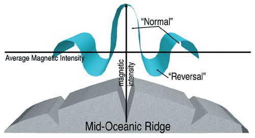 Figure 46: Magnetic Anomalies. Notice the fluctuations in magnetic intensity as one moves across the Mid-Oceanic Ridge. The so-called reversals are simply regions of lower magnetic intensity. Why should the intensity usually be greatest along the crest of the ridge? That explanation is wrong, as detailed magnetic maps clearly show. There are no magnetic reversals on the ocean floor, and no compass would reverse direction if brought near an alleged reversed band. However, as one moves across the Mid-Oceanic Ridge, magnetic intensities fluctuate, as shown in Figure 46. Someone merely drew a line through these fluctuations and labeled everything below this average intensity as a reversal. The false but widespread impression exists that these slight deviations below the average represent a reversed magnetic field millions of years ago. Calling these fluctuations reversals causes one to completely miss a more likely explanation for the magnetic anomalies. Although textbooks show these so-called reversals as smooth bands paralleling the Mid-Oceanic Ridge, there is nothing smooth about them. Some bands are even perpendicular to the ridge axisthe opposite of what plate tectonics predicts. Also, the perpendicular bands correspond to fracture zones.9 The hydroplate theory offers an explanation for these magnetic anomalies. On the continents, rapid but limited changes in earths magnetic field have occurred. Lava cools at known rates, from the outside of the flow toward its center. Magnetic particles floating in lava align themselves with the earths magnetic field. When the lava cools and solidifies, that orientation becomes fixed. Knowing this cooling rate and measuring the changing direction of the magnetic fields throughout several solidified lava flows, we can see that at one time the earths magnetic field changed rapidlyby up to 6 degrees per day for several days.10 Submarine Canyons. The ocean floor has several hundred canyons, some of which exceed the Grand Canyon in both length and depth. One submarine canyon is ten times longer (2,300 miles), so long it would stretch nearly across the United States. Most of these V-shaped canyons are extensions of major rivers. Examples include the Amazon Canyon, Hudson Canyon, Ganges Canyon, Congo Canyon, and Indus Canyon. What could gouge out canyons 15,000 feet below sea level? Perhaps ancient rivers cut these canyons when the ocean floor was higher or sea level was lower. If so, how did that happen? Swift rivers supposedly cut most continental canyons. However, currents measured in submarine canyons are much too slow, generally less than one mile per hour. Frequently, the flow is in the wrong direction. Submarine landslides or currents of dense, muddy water sometimes occur. However, they would not form long, branching patterns that characterize river systems and submarine canyons. Furthermore, experiments with thick, muddy water in submarine canyons have not demonstrated any canyon-cutting ability. Coal and Oil Formations. Large fossilized trees are found near the North and South Poles.11 In Antarctica, some trees are 24 feet long and 2 feet thick! Nearby are 30 layers of anthracite (or high-grade) coal, each 34 feet thick.12 Buried redwood forests, with trees more than 100 feet long and root structures showing they grew in place, are found on Canadian islands well inside the Arctic Circle.13 Much oil is also found inside the Arctic Circle. Was it once warm enough for trees to grow inside Antarctica or the Arctic Circle? If so, how could so much vegetation grow where it is nighttime 6 months of the year? Were these cold lands once at temperate latitudes? Not according to plate tectonics, which places both regions near their present latitudes when their now-fossilized forests were growing.14 Methane Hydrates. Some bacteria live without oxygen. They feed on organic matter and produce methane gas, a combustible fuel. Since the 1970s, methane has been discovered in ice lying on, or hundreds of feet below, the deep ocean floor off coastlines. The ice molecules form tiny cagelike structures containing one or more methane molecules. The total energy value of this methane-ice combination, called methane hydrate, may be twice that in all the worlds known coal, oil, and natural gas combined!15 |
|
|
|
|
Logged
|
Joh 9:4 I must work the works of him that sent me, while it is day: the night cometh, when no man can work.
|
|
|
|
Soldier4Christ
|
|
« Reply #81 on: April 07, 2006, 06:27:33 AM » |
|
(Figure 47 purposefully left out)
Figure 47: Flaming Ice. This ice contains methane, a flammable gas. Water will freeze at slightly warmer temperatures if it is under high pressure and contains dissolved methane. Such temperatures and pressures exist 2,000 feet or more below sea level. There, vast methane deposits are found trapped in ice on and under the deep sea floor, but primarily along coast lines. This methane is escaping into the atmosphere at a rate that would be dangerous if it continued for a million years or so. How did so much methane get there?
Why is so much methane buried along coastlines? How did all those bacteria get there, and what was their gigantic source of food? The largest single deposit known, named Hydrate Ridge, lies off Oregons coast. That part of the seafloor, according to plate tectonics, is sliding under North America. If so, why is so much methane hydrate along Oregons coast, just as it is along other coasts worldwide where seafloors are supposedly not subducting? [See Figure 47.]
|
|
|
|
|
Logged
|
Joh 9:4 I must work the works of him that sent me, while it is day: the night cometh, when no man can work.
|
|
|
|
Soldier4Christ
|
|
« Reply #82 on: April 07, 2006, 06:29:04 AM » |
|
Ice Age. An ice age implies extreme snowfall which, in turn, requires cold temperatures and heavy precipitation. Heavy precipitation can occur only if oceans are warm enough to produce equally heavy evaporation. How could warm oceans exist with cold atmospheric temperatures?
Another problem is stopping an ice age once it beginsor beginning a new ice age after one ends. As glaciers expand, they reflect more of the Suns radiation away from earth, lowering temperatures and causing glaciers to grow even more. Eventually the entire globe should freeze. Conversely, if glaciers shrink, as they have in recent decades, the earth should reflect less heat into space, warm up, and melt all glaciers forever.
Frozen Mammoths. Fleshy remains of about 50 elephant-like animals called mammoths, and a few rhinoceroses, have been found frozen and buried in Siberia and Alaska. One mammoth still had identifiable food in its mouth and digestive tract. To reproduce this result, one would have to suddenly push a well-fed elephant (dead or alive) into a very large freezer that had, somehow, been precooled to -150°F. Anything less severe would result in the animals internal heat and stomach acids destroying the food. If the animal remained alive for more than a few minutes, one would not expect to find food in its mouth. What could cause such a large and sudden temperature drop? Even if the Sun suddenly stopped shining, the earths temperature would not drop rapidly enough to produce such effects. Finally, these giant animals would have to be buried in what was presumably frozen groundquite a trick.
How could large herds of elephant-like animals, each requiring much food, live in the Arctic? Even if the Arctic were warm, the lack of winter sunlight would allow far less vegetation to grow than is needed to sustain so many large animals. Today the average January temperature in northern Siberia is -28°F. Your nose gets cold after a few minutes in +32°F weather. Consider how you would feel if your nose were a 6-foot-long trunk and the average temperature were a frigid 60°F colder for weeks. Where would you, or a mammoth, find drinking water?
Major Mountain Ranges. How did mountains form? Major mountains are often crumpled like an accordion. [See Figure 48.] Satellite photos of mountain ranges show that some resemble rugs that have been pushed against walls. But what force could push a long, thick slab of rock and cause it to buckle and sometimes fold back on itself? Even if a large enough force could be found to overcome the friction at the base of the slab, that force would crush the end being pushed before movement could even begin. Consequently, a mountain would not form.
We can see, especially in mountains and road cuts, thinly layered rocks folded like doubled-over phone books. Other bent rocks are small enough to hold in ones hand. The tiny, crystalline grains in those folds are not stretched. So how could brittle rock, showing little evidence of heating or cracking, fold? Rocks are strong in compression but weak in tension. Therefore, their stretched outer surfaces should easily fracture. Bent rocks, found worldwide, often look as if they had the consistency of putty when they were compressed. They must have been squeezed and folded soon after the sediments were laid down, but before they hardened chemically. What squeezed and folded them?
(Figure 48 purposefully left out)
Figure 48: Buckled Mountains. Textbooks and museums frequently refer to some uplifting force that formed mountains. Can you see that an uplifting force, by itself, could not cause this pattern? Horizontal compression was needed to buckle these sedimentary layers near the Sullivan River in southern British Columbia, Canada. The layers must have been soft, like wet sand, at the time of compression. Today, surface rocks are brittle.
|
|
|
|
|
Logged
|
Joh 9:4 I must work the works of him that sent me, while it is day: the night cometh, when no man can work.
|
|
|
|
Soldier4Christ
|
|
« Reply #83 on: April 07, 2006, 06:29:45 AM » |
|
Overthrusts. A similar problem exists for large blocks of rock called overthrusts that appear to have slid horizontally over other rocks for many miles. Such large sliding blocks should have considerable rubble under them. Many have none.
Standard geology has never adequately explained why overthrusts occur. Again, anything pushing a large slab of rock with enough force to overcome frictional resistance would crush the slab before it would move. [See the technical note on page 355.] Those who appreciate this problem simply say that the pore pressure of water in the rocks lubricated the sliding, and perhaps the slab slid downhill. What is overlooked is that rocks do not contain nearly enough water to do this, and overthrusted blocks are seldom on steep slopes.
Volcanoes and Lava. Erupting lava usually exceeds 2,000°F. Where does it come from, and why is it so hot? The earths mantle and inner core are essentially solid. Only the outer core, which lies 1,8003,200 miles below the earths surface, is a liquid. The standard explanation is that lava (called magma when it is inside the earth) originates in hot pockets, called magma chambers, at depths of about 60 miles. How could magma escape to the surface? A key fact to remember is that at depths greater than about 5 miles, pressures are so great that all empty channels through which magma might rise should be squeezed shut. Even if a crack could open, the magma must rise through colder rock. Unless this happened quite rapidly, magma would cool, solidify, and plug up the crack. Also, heat diffuses. So what concentrated enough heat to create the hot pockets and melt the vast volumes of rock that erupted in the past?
On the Columbia Plateau in the northwestern United States, 64,000 square miles of lava, with an average depth of 2/3 mile, spilled out rapidly under water.16 On the Deccan Plateau in western India, 200,000 square miles have been flooded with lava to an average depth of 3/4 mile. In southwestern Siberia, lava deposits are many times larger. The floor of the Pacific has even larger examples. Escaping magma at the Ontong-Java Plateau, on the floor of the western Pacific, was 25 times more extensive than on the Deccan Plateau. How did so much magma form, and how did it get out?
The worlds two deepest holes in hard basement rock are on the Kola Peninsula in northern Russia and in Germanys northeastern Bavaria.17 They were drilled to depths of 7.5 miles and 5.7 miles, respectively. (Such deep holes, when quickly filled with water or dense mud, will stay open.) Neither hole reached the basalt underlying the granite continents. Deep in the Russian hole, to everyones surprise, was hot, salty water flowing through crushed granite.18 Why was the granite crushed? In the German hole, the drill encountered cracks throughout the lower few miles. All contained salt water having concentrations about twice that of seawater. Remember, surface waters cannot seep deeper than 5 miles, because the weight of overlying rock squeezes shut even microscopic flow channels. While geologists are mystified by this deep salt water, the hydroplate theory provides a simple answer.
Another surprise at these drill sites was the greater-than-expected increase in the granites temperature with increased depth. This raises the question of why the earths crust is so hot.
Geothermal Heat. Heat inside the earth is called geothermal heat. In general, the deeper man has gone into the earthfirst in deep caves and mines and later with drillsthe hotter the rock gets. What is the origin of geothermal heat? As children, most of us were taught the early earth was molten. Later, we were told the earth slowly grew (evolved) by meteoritic impacts whose energy made the earth molten.
This popular story has several problems. First, the rate of temperature increase with depth, called the temperature gradient, varies at different locations by a factor of six.19 This is true even when considering only continental rock far from volcanoes. The deep drilling in Russia and Germany encountered rock so much hotter than expected that each project was terminated earlier than planned. If the earth has been cooling for billions of years, one would expect very uniform temperature increases with depth. Unusually hot or cold regions should not exist, because heat diffuses from hotter to colder regions.
Had the earth ever been molten, denser materials would have sunk toward the earths center, and lighter materials would have floated to the surface. One should not find dense, fairly nonreactive metals, such as gold, at the earths surface. [See Molten Earth? on page 79.] Even granite, the basic continental rock, is a mixture of many minerals with varying densities. If melted granite slowly cooled, a layer cake of vertically sorted minerals would form instead of granite. So earths crust was never molten.
Mathematical solutions for heat conduction in spheres, such as the earth, are well known. These solutions can incorporate many facts, such as the earths thermal properties, radioactive heat generation, and temperatures at the earths surface. Such analyses are hopelessly inconsistent with the molten-earth story and billions of years of cooling. [See Molten Earth? on page 25 and Rapid Cooling on page 35.] What then generated geothermal heat, and why does it vary so widely?
Strata. Earths crust is frequently stratified with layered rock (or strata) composed of cemented sediments. These layers, called sedimentary rock, are typically uniform, parallel, vast in area, thin, and tipped at all angles within mountains and under valleys. Often one layer rests on another having a completely different texture, color, and mineral content. What global process could have sorted and cemented these sediments? Present processes do not.
Why are strata so uniform in hardness? If truckloads of sand and other dry sediments were dumped on your yard and bags of cement were placed in another pile, anyone would have difficulty mixing them uniformly. Without a uniform mixture of cementing agent, concrete (and sedimentary rock) would quickly crumble.
Limestone. A typical cementing agent in sedimentary rock is calcium carbonate (CaCO3)commonly called limestone. Any geologist or mineralogist who stops to think about it should realize the earth has too much limestone, at least based on present processes. Sediments and sedimentary rock on the continents average about a mile in thickness. Between 10 and 15% of this is limestone.20 How did so much limestone formmuch of it quite pure? Limestone, without the impurities that normally drift in, suggests rapid burial. Most limestone is in vast layers, tens of thousands of square miles in area and hundreds of feet thick. Today, limestone forms either by precipitating out of seawater or by sea creatures manufacturing limestone shells and corals. In either case, oceans supply limestone sediments, but oceans already contain about as much dissolved limestone as they can possibly hold. So where did all the limestone come from, especially its calcium and carbon, which are relatively rare outside of limestone?
|
|
|
|
|
Logged
|
Joh 9:4 I must work the works of him that sent me, while it is day: the night cometh, when no man can work.
|
|
|
|
Soldier4Christ
|
|
« Reply #84 on: April 07, 2006, 06:30:28 AM » |
|
Metamorphic Rock. Rocks change structurally and chemically when their temperatures and/or pressures exceed certain high values. The new rock is called a metamorphic rock. For example, limestone becomes marble (a metamorphic rock) when its temperature exceeds 1,600°F and the confining pressure corresponds to the weight of a 23-mile-high column of rock. Diamonds, another metamorphic rock, form under confining pressures corresponding to the weight of a 75-mile-high column of rock and 1,600°F.21 Most metamorphic rocks were formed in the presence of water, often flowing water.22 What caused the extreme temperature, pressure, and abundance of water?
The standard answer is that the original rock, such as limestone, was heated and compressed under a tall mountain or deep in the earth. Later, either the mountain eroded away or the deep rock rose to the earths surface. That would take millions of years. It is difficult to imagine mountains 23 or 75 miles high, because the worlds tallest mountain, Mount Everest, is only 51/2 miles high. Raising buried layers of rock 23 or 75 miles to the earths surface is even more difficult to explain, but with millions of years supposedly available to do it, few consider it a problem; fewer still address the problem. Ignored in this standard explanation is the frequent requirement for water, sometimes flowing water. Surface water, remember, cannot seep deeper in rock than about 5 miles, and even at 5 miles, water hardly flows. Metamorphic rock is a giant enigma.
Plateaus. Plateaus are relatively flat regions of extensive area that have been uplifted more than 500 feet relative to surrounding regions. Professor George C. Kennedy explains the problems associated with plateaus quite well.
The problem of the uplift of large plateau areas is one which has puzzled students of the Earths crust for a very long time. ... Given an Earth with sialic [granitic] continents floating in denser simatic [basaltic] substratum, what mechanism would cause a large volume of low standing continents to rise rapidly a mile in the air? Furthermore, evidence from gravity surveys suggests that the rocks underlying the Colorado plateau are in isostatic balance, that is, this large area is floating at its correct elevation in view of its mass and density. Recent seismic evidence confirms this, in that the depth to the M discontinuity [the Moho, which will be explained later] under the Colorado plateau is approximately 10 kilometers [6 miles] greater than over most of continental North America. Thus, appropriate roots of light rock extend into the dense substratum to account for the higher elevation of the Colorado plateau. We have then a double-ended mystery, for the Colorado plateau seems to have grown downward at the same time that its emerged part rose upward. This is just as startling as it would be to see a floating cork suddenly rise and float a half inch higher in a pan of water. To date, the only hypothesis to explain the upward motion of large regions like the Colorado plateau is that of convection currents. Slowly moving convection currents in the solid rock, some 40 to 50 kilometers [25 to 30 miles] below the surface of the Earth, are presumed to have swept a great volume of light rock from some unidentified place and to have deposited it underneath the Colorado plateau. A total volume of approximately 2,500,000 cubic miles of sialic rock is necessary to account for the uplift of the Colorado plateau. While it is not hard to visualize rocks as having no great strength at the high pressures and temperatures existing at depths of 40 to 50 kilometers, it is quite another matter to visualize currents in solid rock of sufficient magnitude to bring in and deposit this quantity of light material in a relatively uniform layer underneath the entire Colorado plateau region.
The Tibetan plateaus present a similar problem, but on a vastly larger scale. There, an area of 750,000 square miles has been uplifted from approximately sea level to a mean elevation of roughly three miles, and the Himalayan mountain chain bordering this region has floated upward some five miles, and rather late in geologic time, probably within the last 20,000,000 years. The quantity of light rock which would need to be swept underneath these plateaus by convection currents to produce the effects noted would be an order of magnitude greater than that needed to uplift the Colorado plateau, that is approximately 25,000,000 cubic miles. Even more troublesome than the method of transporting all this light rock at shallow depths below the surface of the Earth is the problem of its source. The region from which the light rock was moved should have experienced spectacular subsidence, but no giant neighboring depressions are known. A lesser but large problem is how such enormous quantities of light rock can be dispersed so uniformly over so large an area.23
Salt Domes. At many locations, layers of salt are buried up to several miles below the earths surface, in layers 100,000 square miles in area and in other places a mile in thickness. Often a salt layer has bulged up several miles, like a big underground bubble, to form a salt dome. Large salt deposits are not being laid down today, even in the Great Salt Lake. What concentrated this much salt? Surprisingly large salt deposits lie under the Mediterranean Sea. A codiscoverer of this huge deposit claims the Mediterranean must have evaporated 810 times to deposit so much salt.24 His estimate is probably low, but even so, why didnt each refilling of the Mediterranean basin dissolve the salt residue left from prior evaporations, allowing currents to remove the redissolved salt from the basin?
Jigsaw Fit of the Continents. For centuries, beginning possibly with Francis Bacon in 1620, many have marveled at the apparent jigsaw fit of the continents bordering the Atlantic. It is only natural that bold thinkers, such as Alfred Wegener in 1912, would propose that the continents were once connected as shown in Figure 49, and somehow they broke apart and moved to their present positions. But would continents, which often extend offshore hundreds of miles to the edge of the continental shelf, really fit together as shown in textbooks? Distances are distorted when a globe is flattened into a two-dimensional map. Therefore, to answer this question, I formed two plates on a globe, matching the true shape and curvature of the continents. [See Figure 50.]
|
|
|
|
|
Logged
|
Joh 9:4 I must work the works of him that sent me, while it is day: the night cometh, when no man can work.
|
|
|
|
Soldier4Christ
|
|
« Reply #85 on: April 07, 2006, 06:36:43 AM » |
|
 Figure 49: Continental Fit Proposed by Edward Bullard. Can you identify four distortions in this popular explanation of how the continents once fit together? First, Africa was shrunk in area by 35%. Second, Central America, southern Mexico, and the Caribbean Islands were removed. Third, a slice was made through the Mediterranean, and Europe was rotated counterclockwise and Africa was rotated clockwise. Finally, North and South America were rotated relative to each other. (Notice the rotation of the north-south and east-west lines.) Overlapping areas are shown in black. The classical fit (Figure 49), proposed by Sir Edward Bullard, appears at first glance to be a better fit of the continents than my plates. However, notice in Figure 49s caption the great latitude Bullard took in juggling continents. Were these distortions made to improve the fit? Few, if any, textbooks inform us of these distortions.  Figure 50: Continental Plates Made on a Globe. Notice that the fit of the actual continents is not as good as Bullard proposed. [See Figure 49.] Instead of fitting the continents to each other, notice in Figure 51 how well they each fit the base of the Mid-Atlantic Ridge. The hydroplate theory proposes that: a. These continents were once in the relative positions shown in Figure 51. b. They were connected by rock that was rapidly crushed, eroded, and transported worldwide by erupting subterranean water. c. As these eroded sediments were deposited, they trapped and buried plants and animals. The sediments became todays sedimentary rock; buried organisms became fossils. d. The continents quickly slid on a layer of water (rapid continental drift) away from what is now the Mid-Atlantic Ridge and came to rest near their present locations. Details and evidence will be given later.  Figure 51: Continental Plates on a Globe. By far the best fit of the continents is with the base of the Mid-Atlantic Ridgenot with other continents, as shown in Figure 50. |
|
|
|
|
Logged
|
Joh 9:4 I must work the works of him that sent me, while it is day: the night cometh, when no man can work.
|
|
|
|
Soldier4Christ
|
|
« Reply #86 on: April 07, 2006, 06:37:19 AM » |
|
Layered Fossils. Fossils rarely form today, because dead plants and animals decay before they are buried in enough sediments to preserve their shapes. We certainly do not observe fossils forming in layered strata that can be traced over thousands of square miles. So how did so many fossils form? It will soon become apparent why animals and plants were trapped and buried in sediments that were quickly cemented to form the fossil record and why fossils of sea life are on every major mountain range.
Changing Axis Tilt. George F. Dodwell served as the Government Astronomer for South Australia from 1909 to 1952. In the mid-1930s, he became interested in past changes in the tilt of the earths axis. He collected 66 astronomical measurements made over a 4,000-year period. During those years, the tilt of the earths axis smoothly decayed from 25°10' to its present value of 23°27'. Based on the shape of the decay curve, Dodwell estimated that this axis shift began in about the year 2345 B.C.25
Although the gravitational forces of the Sun, Moon or planets can change the tilt of the earths axis, such changes are much slower than Dodwell measured. Extraterrestrial bodies striking the earth would provide an abrupt change in axis orientation, not the steady pattern of decay Dodwell measured. Furthermore, only a massive and fast asteroid striking the earth at a favorable angle would tilt the axis this much. The resulting pressure pulse would pass through the entire atmosphere and quickly kill most air-breathing animalsa recent extinction without evidence.
Comets, Asteroids, and Meteorites. These strange bodies, sometimes called the mavericks of the solar system, have several remarkable similarities with planet earth. About 38% of a comets mass is frozen water. Water is rare in the universe, but both common and concentrated on earthsometimes called the water planet. Much of the remaining 62% of each comets mass is dust, primarily the crystalline mineral olivine. Solid material that formed in space would not be crystalline. Olivine is probably the most abundant of the more than 2,000 known minerals on earth. Asteroids and meteorites are rocks similar in many ways to earth rocks. Surprisingly, some meteorites contain salt crystals, liquid water, and living bacteria. Some asteroids appear to have the residue of plant life.
Summary. These are a few of the mysteries associated with the 24 topics listed on page 102. The hydroplate theory will explain these mysteries and tie together the causes and effects of this dramatic, global catastrophe.
|
|
|
|
|
Logged
|
Joh 9:4 I must work the works of him that sent me, while it is day: the night cometh, when no man can work.
|
|
|
|
Soldier4Christ
|
|
« Reply #87 on: April 07, 2006, 06:38:04 AM » |
|
How to Evaluate Theories
To explain scientifically an unobserved event that cannot be repeated, we must first assume the conditions existing before that event. From these assumed starting conditions, we then try to determine what should happen according to the laws of physics. Three criteria should then be used to evaluate the proposed explanation.
Criterion 1: Process. If we can explain all relevant observations better than any other proposed explanation, confidence in our explanation increases. However, if these starting conditions and the operation of physical laws (or known processes) should have produced results that are not present, then confidence in our explanation decreases.
For example, a frequent and intriguing question is, What caused the extinction of the dinosaurs? (We will not address that question now, but will use it to show how to evaluate scientific theories attempting to explain unobserved and unrepeatable events.) Some dinosaur extinction theories assume large climatic changes. While many types of climate variation might kill all dinosaurs, we must also (by Criterion 1) look at other consequences of large climatic changes. Flowering plants and many small animals are even more vulnerable to large climatic changes. Because most plants and animals did not become extinct with the dinosaurs, climatic change theories for dinosaur extinctions are weakened.
Criterion 2: Parsimony. (Parsimony here means the use of few assumptions.) If a few assumptions allow us to explain many things, then confidence in the explanation will be great. Conversely, if many assumptions are used to explain a few observations, or if we must continually add new assumptions or modify our proposed theory as new observations are made, then we should have little confidence in the explanation.
For example, some say a large asteroid or comet struck the earth and killed all the dinosaurs. Supposedly, the asteroid or comet, containing the rare element iridium, kicked up a worldwide dust cloud that blocked sunlight for several years, reduced photosynthesis on earth, and choked off the dinosaurs food chain. Support for this theory comes from layers of clay in Europe, New Zealand, and elsewhere containing iridium. Iridium-rich layers are found near many dinosaur fossils and are dated, using evolutionary assumptions, as about 65 million years old. An asteroid or comet striking the earth might explain the worldwide extinction of the dinosaurs and widespread iridium layers near many dinosaur fossils. In other words, one starting condition (an impact of a large asteroid or comet) explains two important observations: dinosaur extinctions and iridium layers. This is good.
But there are some hidden assumptions. While most meteorites contain iridium, it has not been detected in asteroids or comets. So advocates of the impact theory must assume that asteroids or comets have large amounts of iridium (or that meteorites came from asteroids). Other iridium-rich layers have since been discovered too far above and below the layer thought to mark the extinction of the dinosaurs. Further studies have found few iridium-rich layers near known impact craters. (Surprisingly, scientists later learned that airborne particles expelled by volcanoes contain considerable iridium and other rare chemical elements in the iridium-rich layers.)26
Also, many marine plants require daily sunlight.27 How could they have survived a global dust cloud that killed the dinosaurs? Each problem can be solved by making new assumptions. However, by Criterion 2, this reduces our confidence in the theory.
Criterion 3: Prediction. A legitimate theory allows us to predict unusual things we should soon see if we look in the right places and make the right measurements. Verified predictions will greatly increase our confidence in an explanation. Published predictions are the most important test of any scientific theory. Few evolutionists make predictions.
What predictions can be made based on the climatic variation and impact theories? Few, if any, have been made publicly. This does not inspire confidence in these explanations. Rarely do predictions accompany explanations of ancient, unobserved events.
Some predictions can be associated with the impact theory. For example, a very large impact crater should be found whose age corresponds to the time of the extinction of the dinosaurs. Extinctions and fossils of many forms of life should concentrate near the crater or, at least, in the hemisphere containing the crater. However, it is recognized that other fossils and extinctions that accompanied the dinosaurs demise are uniformly distributed worldwide,28 a point worth remembering.
For several years, no suitable crater could be found.29 Finally, in 1990, an impact site was proposed on Mexicos Yucatán Peninsula, centered near the village of Chicxulub (CHICK shoo loob). Evolutionists initially dated the site as 4050 million years before dinosaurs became extinct. No crater shape was visible. Later, a buried crater was claimed based on slightly circular magnetic and gravitational patterns, much imagination, and the desire to explain dinosaur extinctions. Impact advocates then redated the region and, in effect, predicted that drilling in and around Chicxulub would reveal an iridium layer and a buried impact crater. Later drilling projects found neither.30
Other dinosaur extinction theories have even more problems. Our purpose in this section is not to settle this issue but to show how scientific reasoning should be applied to unobserved, nonreproducible events. Incidentally, another theory on dinosaur extinction will soon become obviousa theory involving a global flood and the harsh conditions afterward. [For more on dinosaurs, see What about the Dinosaurs? on page 288.]
Scientific explanations are never certain or final, and the overused word prove is never justified except possibly in mathematics or a court of law. Science is even less certain when dealing with ancient, unrepeatable events, because other starting conditions might work as well or better than the proposed starting conditions. Perhaps we have overlooked a physical consequence or have improperly applied the laws of physics. Certainly we can never consider all the possibilities or have all the data.
So to try to scientifically understand unobservable, unrepeatable events, we should consider many sets of starting conditions, estimate the consequences of each based on physical laws, and then see how well those consequences meet the above three criteria. Ancient records, such as legends or the Mosaic account in the Bible, do not give scientific support for the truth or falsity of an ancient event. Such records may provide important historical support to those with confidence in a particular ancient record. This, however, is not science. Here in Part II, we will focus on science.
|
|
|
|
|
Logged
|
Joh 9:4 I must work the works of him that sent me, while it is day: the night cometh, when no man can work.
|
|
|
|
Soldier4Christ
|
|
« Reply #88 on: April 07, 2006, 06:40:01 AM » |
|
The Hydroplate Theory: Key Assumption
Starting assumptions, as explained above, are always required to explain ancient, unrepeatable events. One starting assumption underlies the hydroplate theory. All else follows from that assumption and the laws of physics. Theories of past events always have some initial conditions. Usually they are not mentioned.
(Figure 52 purposefully left out)
Figure 52: Granite and Basalt. Granite, the dominant continental rock, has a grayish-to-pinkish color. Coarse grains of quartz, which have a glassy luster, occupy about 27% of granites volume. Basalt, the dominant rock beneath oceans, is a dark, fine-grained rock. The hydroplate theory assumes that before the flood, granite was above the subterranean water and basalt was below the water.
Assumption: Subterranean Water. About half the water now in the oceans was once in interconnected chambers about 10 miles below the earths surface. Excluding the extensive solid structure of these chambers, which will be called pillars, the subterranean water was like a thin, spherical shell, averaging about 3/4 of a mile in thickness. Above the subterranean water was a granite crust; beneath the water was a layer of basaltic rock. [See Figure 53.]
Europe, Asia, Africa, and the Americas were generally in the positions shown in Figure 51 on page 109, but were joined across what is now the Atlantic Ocean. On the preflood crust were seas, both deep and shallow, and mountains, generally smaller than those of today, but some perhaps 5,000 feet high.
|
|
|
|
|
Logged
|
Joh 9:4 I must work the works of him that sent me, while it is day: the night cometh, when no man can work.
|
|
|
|
Soldier4Christ
|
|
« Reply #89 on: April 07, 2006, 06:40:52 AM » |
|
Two Common Questions
Those not familiar with the behavior of high-pressure fluids sometimes raise two questions.
1. How could rock float on water? The crust did not float on water; water was trapped and sealed under the crust. (Pillars also helped support the crust.) The crust was like a thin slab of rock resting on and covering an entire waterbed. As long as the water mattress does not rupture, a dense slab will rest on top of less-dense water. Unlike a waterbeds seal, which is only a thin sheet of rubber, the chambers seal was compressed rock almost 10 miles thick. Pressures in the crust 5 miles or more below the earths surface are so great that the rock can deform like highly compressed, extremely stiff putty. The slightest crack or opening, even around a small chunk of rock, could not open from below.
2. Temperatures increase with depth under the earths surface. Subterranean water at a depth of about 10 miles would have been extremely hot. Wouldnt all life on earth have been scalded if that water flooded the earth? No. Events related to the flood generated todays geothermal heat. To understand why and to see why life was not scalded, one must first understand tidal pumping and supercritical water (SCW). One should also understand, as explained on page 302, why continents and preflood mountains sank as the subterranean water escaped.
Tidal Pumping. Tides in the subterranean water lifted the massive crust twice daily. Each tidal lift transferred energy from the earths spin to the crust. At low tides, the crust settled, compressing and heating the pillars. Calculations show that temperatures in the subterranean chamber steadily rose, generating some of the heat under the earths surface today. Some gases and minerals dissolved in this hot, high-pressure, liquid water, especially carbon dioxide (CO2), salt (NaCl), and quartz (SiO2). (In a few chapters, you will see why dissolved quartz petrified some wood and cemented flood sediments into sedimentary rocks.)
SCW. At a pressure of one atmospherealso called 1.0 bar or 14.7 psi (pounds per square inch)liquid water boils at a temperature slightly above 212°F (100°C). As pressure increases, the boiling temperature rises. At a pressure of 220.6 bars (3,200 psi) the boiling temperature is 705°F (374°C). Above this pressure-temperature combination, water becomes supercritical and cannot boil. SCW has other interesting and important properties.
After centuries of tidal pumping, the subterranean water exceeded the critical temperature (705°F). The initial pressure in the 10-mile-deep subterranean chamber would have been about 4,270 bars (62,000 psi)well above the critical pressure. As the temperature increased, pressure also grewand the crust stretched.
SCW can dissolve much more salt (NaCl) per unit volume than normal waterup to about 840°F (450°C). At higher temperatures, all salt precipitates out.31 (In a few pages, this fact will help explain how so much salt was concentrated on the earth and how salt domes formed.)
Most hot liquids cool primarily by evaporation from their surfaces.32 SCW consists of microscopic liquidlike clusters dispersed within water vapor. The rate those hot clusters and most hot objects cool off depends on their total surface area. The smaller a particle is, the larger its surface area is relative to its volume, so more of its heat can be quickly transferred to its surroundings. The liquid in SCW has an area-to-volume ratio that is a trillion times greater (1012) than that of water that might have covered the earths surface. Consequently, the liquid in SCW cools almost instantaneously if its pressure drops. This is because the myriad of liquid clusters, each surrounded by vapor, can simultaneously evaporate. A typical SCW cluster at 300 bars and 716°F (380°C) consists of 510 molecules with a volume of only 2733 cubic angstroms. These liquidlike clusters break up and reform continuously.33
This explains how the escaping supercritical liquid transferred its energy into supercritical vapor. How did the vapor lose its energy and cool? Rapid expansion. A remarkable characteristic of supercritical fluids is that a small decrease in pressure produces a large change in volume. So as the SCW flowed toward the base of the rupture, its pressure dropped and the vapor expanded and cooled. As it expanded, it pushed on the surrounding fluid (gas and liquid), giving all fluid downstream greater kinetic energy.
Eventually the horizontally flowing liquid-gas mixture began to flow upward through the rupture. As the fluid rose, its pressure dropped to almost zero in seconds. The 5,000-fold expansion resembled a focused explosion of indescribable magnitude, accelerating the mixture, including rocks and dirt, into the vacuum of space.
In summary, during the flood SCW accelerated out of the chamber and up through a globe-encircling rupture in the crustas from a ruptured pressure cooker. This tremendous acceleration expanded the spacing between water molecules, allowing flash evaporation, sudden cooling, and even greater expansion, acceleration, and cooling. Therefore, most of the extreme thermal energy in the subterranean water ended up not as heat at the earths surface but as extreme kinetic energy in all the fountains of the great deep. As you will see, these velocities were high enough to launch much material into outer spacethe final dumping ground for most of the energy in the SCW.
|
|
|
|
|
Logged
|
Joh 9:4 I must work the works of him that sent me, while it is day: the night cometh, when no man can work.
|
|
|
|


