|
Soldier4Christ
|
 |
« Reply #90 on: April 07, 2006, 06:42:52 AM » |
|
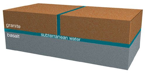
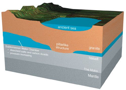 Figure 53: Cross Section of the Preflood Earth. Several aspects of the early earth are shown here. The chambers thickness (exaggerated in the figure) varied. Pillarlike formations, connecting the chambers floor and roof, partially supported the roof. (Subterranean water also provided support.) Unlike the cylindrical columns we see in buildings, subterranean pillars were tapered downward. Pages 300304 explain how, why, and when pillars formed. Below the basalt was the top of the earths mantle. An important distinction between the basalt and upper mantle was discovered in 1909 by seismologist Andrija Mohorovicic. He noticed that earthquake waves passing into the mantle suddenly increased in speed. This boundary is now called the Mohorovicic discontinuity, a term which, for obvious reasons, been shortened to the Moho. All 24 major mysteries described earlier, such as major mountain ranges, ice ages, comets, and the Grand Canyon, seem to be consequences of this basic assumption. The chain of events that flows naturally from this starting condition will now be described as an observer might relate them. The events fall into four phases. |
|
|
|
|
 Logged
|
Joh 9:4 I must work the works of him that sent me, while it is day: the night cometh, when no man can work.
|
|
|
|
Soldier4Christ
|
|
« Reply #91 on: April 07, 2006, 06:49:29 AM » |
|
Phases of the Hydroplate Theory: Rupture, Flood, Drift, and Recovery 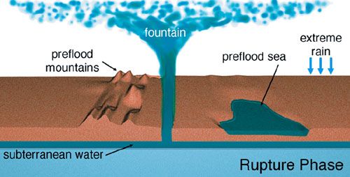 Figure 54: Rupture Phase of the Flood. This 46,000-mile-long rupture encircled the earth near what is now the Mid-Oceanic Ridge. Rupture Phase. The increasing pressure in the subterranean water stretched the overlying crust, just as a balloon stretches when the pressure inside increases. Eventually, this shell of rock reached its failure point. Failure began with a microscopic crack at the earths surface. Because stresses in such cracks are concentrated at each end of the crack, each end grew rapidlyat about 2 miles per second.34 Within seconds, this crack penetrated down to the subterranean chamber and then followed the path of least resistance around the earth. The ends of the crack, traveling in opposite directions, circled the earth in 23 hours.35 Initial stresses were largely relieved when one end of the crack ran into the path left by the other end. In other words, the crack traveled a path that intersected itself at a large angle, forming a T or Y somewhere on the opposite side of the earth from where the rupture began. As the crack raced around the earth, the 10-mile-thick crust opened like a rip in a tightly stretched cloth. Pressure in the subterranean chamber immediately beneath the rupture suddenly dropped to nearly atmospheric pressure. Supercritical water exploded with great violence out of the 10-mile-deep slit that wrapped around the earth like the seam of a baseball. 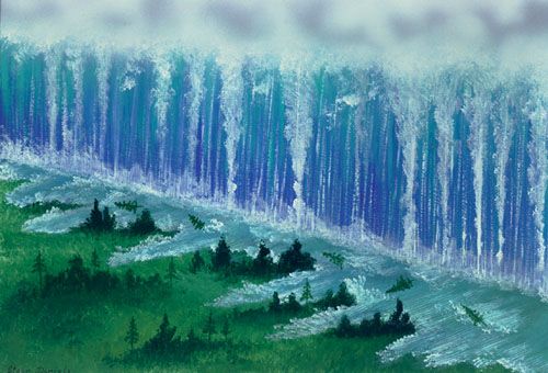 Figure 55: Jetting Fountains. For a global perspective of what this may have looked like, see page 99. All along this globe-circling rupture, whose path approximates todays Mid-Oceanic Ridge,36 a fountain of water jetted supersonically into and far above the atmosphere. Much of the water fragmented into an ocean of droplets that fell as rain great distances away. This produced torrential rains such as the earth has never experiencedbefore or after. Some jetting water rose above the atmosphere where it froze and then fell on various regions of the earth as huge masses of extremely cold, muddy hail. That hail buried, suffocated, and froze many animals, including some mammoths. [For details, see Frozen Mammoths on pages 178205.] The most powerful jetting water and rock debris escaped the earths gravity and became the solar systems comets, asteroids, and meteoroids. [For details, see The Origin of Comets on pages 208237, and The Origin of Asteroids and Meteoroids on pages 240256.] 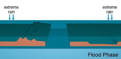 Figure 56: Flood Phase. Sediments in the escaping water increased until their volume nearly equaled the volume of water gushing out. These suspended particles quickly settled and buried plants and animals in a chaotic mixture. During this phase, a phenomenon called liquefaction sorted sediments, animals, and plants into horizontal layers that are more uniform and cover a much larger area than sedimentary layers laid down today. Traces of these dead organisms are called fossils. Global liquefaction is explained on pages 158168. Flood Phase. Each side of the rupture was basically a 10-mile-high cliff. Compressive, vibrating37 loads in the bottom half of the cliff face greatly exceeded the rocks crushing strength, so the bottom half of the cliff continuously crumbled, collapsed, and spilled out into the jetting fountains. That removed support for the top half of the cliff, so it also fragmented and fell into the pulverizing supersonic flow. Consequently, the 46,000-mile-long rupture rapidly widened to an average of about 800 miles all around the earth. About 35% of the eroded sediments were from the basalt of the chamber floor.38 Sediments swept up in the escaping flood waters gave the water a thick, muddy consistency. These sediments settled out over the earths surface in days, trapping and burying many plants and animals, beginning the process of forming the worlds fossils. The rising flood waters eventually blanketed the water jetting from the rupture, although water still surged out of the rupture. Because todays major mountains had not yet formed, global flooding covered the earths relatively smooth topography. As explained on page 112, salt precipitated out of the supercritical subterranean water before the flood began, blanketing the chamber floor with solid, but mushy, salt. Much of it was swept out of the chambers by the escaping water, ending up as layers of salt in the flood deposited sediments. As other sediments, which were all denser, blanketed the pasty, low-density salt, an unstable arrangement arose, much like having a layer of light oil beneath a denser layer of water. A slight jiggle will cause the lighter layer below to flow up as a plume through the denser layer above. In the case of salt, that plume is called a salt dome. |
|
|
|
|
Logged
|
Joh 9:4 I must work the works of him that sent me, while it is day: the night cometh, when no man can work.
|
|
|
|
Soldier4Christ
|
|
« Reply #92 on: April 07, 2006, 06:53:59 AM » |
|
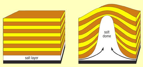 Figure 57: Salt Dome. Just as a cork released at the bottom of a swimming pool will float up through water, wet salt can float up through denser sediments. It begins when a small part of a wet salt layer rises. That causes other salt in the layer to flow horizontally and then up into a rising plume, called a salt dome. If the salt and sediments are mushy and saturated with water, friction offers little resistance. The upturned (or bowl-shaped) layers next to the salt dome can become traps in which oil collects, so understanding salt domes has great economic value. The waters pressure decreased as it rose out of the subterranean chamber. Because high-pressure liquids can hold more dissolved gases than low-pressure liquids, gases quickly escaped. A similar process occurs when a pressurized can of carbonated beverage is opened, quickly releasing bubbles of dissolved carbon dioxide. From the subterranean waters, the most significant gas that came out of solution was carbon dioxide. This venting accompanied the precipitation of limestone. [See The Origin of Limestone on pages 170175.] Flooding uprooted most of earths abundant vegetation and transported it to regions where it accumulated in great masses. [Pages 158168 explain how this vegetation was collected and sorted into thin layers within the sediments.] Later, at the end of the continental-drift phase, buried layers of vegetation were rapidly compressed and heated, precisely the conditions that laboratory experiments have shown will form coal and oil.41 The flood phase ended with the continents near the positions shown in Figure 51 and the top frame of Figure 61. 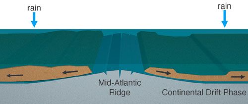 Figure 58: Continental-Drift Phase of the Flood. Continental-Drift Phase. Material within the earth is compressed by overlying rock. Rocks slight elasticity gives it springlike characteristics.42 The deeper the rock, the more weight above, so the more tightly compressed the springall the way down to the center of the earth. The rupture path continuously widened during the flood phase. [See Figure 59e.] Eventually, the width was so great, and so much of the surface weight had been removed, that the compressed rock beneath the exposed floor of the subterranean chamber sprung upward. [See Figure 59f.] As the Mid-Atlantic Ridge began to rise, creating slopes on either side, the granite hydroplates started to slide downhill. This removed even more weight from what was to become the floor of the Atlantic Ocean. As weight was removed, the floor rose faster and the slopes increased, so the hydroplates accelerated, removing even more weight, etc. The entire Atlantic floor rapidly rose almost 10 miles. |
|
|
|
|
Logged
|
Joh 9:4 I must work the works of him that sent me, while it is day: the night cometh, when no man can work.
|
|
|
|
Soldier4Christ
|
|
« Reply #93 on: April 07, 2006, 07:03:20 AM » |
|
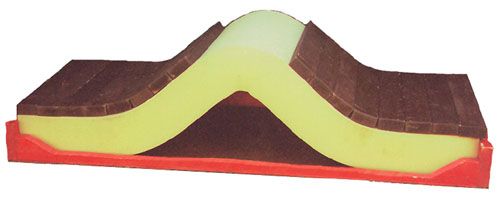
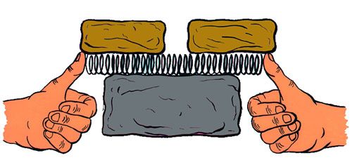  a) Overlying rocks keep a compressed spring horizontal. d) Rupture completed. Jetting water not shown. 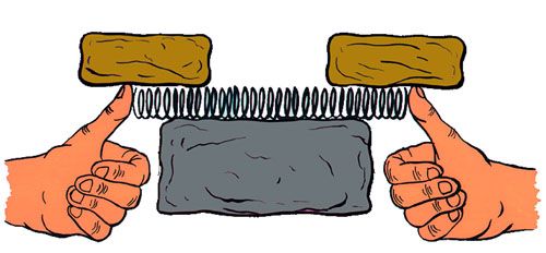 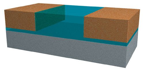 b) The spring remains aligned and compressed as the gap between the rocks widens. e) The ruptures path widens by the crushing, erosion, and collapse of the vertical walls, exposing what will become the Mid-Atlantic Ridge. Most of earths sediments are quickly produced by escaping, high-velocity watersthe fountains of the great deep. 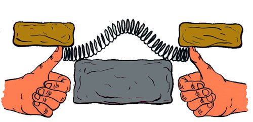 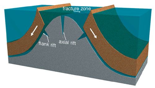 c) When the gap reaches a certain critical width, the spring suddenly buckles upward. Now consider thousands of similar springs lined up behind the first springall linked together and repeating in unison steps ac. The upward buckling of any coil will cause adjacent springs to become unstable and buckle up themselves. They, in turn, will lift the next spring, and so on, in ripple fashion. f) Continental-drift phase begins. The Mid-Atlantic Ridge springs upward, releasing extreme amounts of energy, inherent in compressed rock. Fracture zones form perpendicular to the ridge axis and rifts form along the ridge axis. [See Endnote 43 on page 126.] The massive hydroplates, lubricated by water, begin to accelerate downhill. As more and more weight slides away from the newly formed Ridge, the exposed chamber floor quickly rises several miles (accelerating the hydroplates even more) and becomes the Atlantic floor. Figure 59: Spring Analogy Showing Development of the Mid-Atlantic Ridge. |
|
|
|
|
Logged
|
Joh 9:4 I must work the works of him that sent me, while it is day: the night cometh, when no man can work.
|
|
|
|
Soldier4Christ
|
|
« Reply #94 on: April 07, 2006, 07:07:39 AM » |
|
As the first segment of the Mid-Atlantic Ridge began to rise, it helped lift adjacent portions of the chamber floor just enough for them to become unstable and spring upward. This process continued all along the rupture path, forming the Mid-Oceanic Ridge. Also formed were fracture zones and the strange offsets the ridge has at fracture zones.43 Soon afterward, magnetic anomalies (Figure 46 on page 104) developed.44 For a day or so, the sliding hydroplates were almost perfectly lubricated by water still escaping from beneath them. This process resembled the following: A long train sits at one end of a very long, level track. If we could somehow just barely lift the end of the track under the train and the wheels were frictionless, the train would start rolling downhill. Then we could lift the track even higher, causing the train to accelerate even more. If this continued, the high-speed train would eventually crash into something. The long train of boxcars would suddenly decelerate, compress, crush, and jackknife. 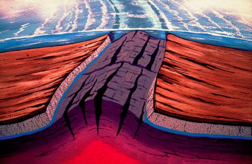 Figure 60: Birth of Mid-Atlantic Ridge. Continental plates accelerated away from the widening Atlantic. (Recall that the rupture encircled the earth, and escaping subterranean water widened that rupture about 400 miles on each side of the rupture, not just on what is now the Atlantic side of the earth but also on the Pacific side. Thus, the plates on opposite sides of the Atlantic could slide at least 400 miles away from the rising Mid-Atlantic Ridge.45 In the next chapter, dramatic events occurring simultaneously in the Pacific will be explained.) Eventually, the driftingactually, acceleratinghydroplates ran into resistances of two types. The first happened as the water lubricant beneath each sliding plate was depleted. The second occurred when a plate collided with something. As each massive hydroplate decelerated, it experienced a gigantic compression eventbuckling, crushing, and thickening each plate. 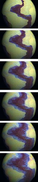 Figure 61: Computer Animation of the Continental-Drift Phase. The top frame shows one side of the earth at the end of the flood phase. Because the rupture encircled the earth, a similar eroded gap existed between the continental plates on the other side of the globe. The Mid-Oceanic Ridge rose first in the Atlantic, hours or days before the ridge traveled to and rose in what is now the Pacific. This caused the hydroplates to accelerate downhill on a layer of lubricating water, away from the widening Atlantic and into the gap on the opposite side of the earth. The continental-drift phase ended (bottom frame) with the dramatic compression event that squeezed up the earths major mountains. These six frames simply rotate the present continents about todays polar axis. Therefore, greater movement occurs at lower latitudes. Movement begins from where the continents best fit against the base of the Mid-Atlantic Ridge (see Figure 51 on page 109) and ends near their present locations. Not shown are consequences of the compression event. For example, the compression squeezed and thickened continents, shortening the widths of the major continents and widening the Atlantic. Of course, postflood mountains thickened the most, but nonmountainous regions thickened as well. Regions that did not thicken are now part of the shallow ocean floor. [See Figure 42 on page 103.] While it may seem strange to think of squeezing, thickening, and shortening granite, one must understand the gigantic forces required to decelerate sliding continental plates. If compressive forces are great enough, granite deforms (much like putty) on a global scale. On a human scale, however, one would not see smooth, puttylike deformation; instead, one would see and hear blocks of granite fracturing and sliding over each other. Some blocks would be the size of a small state or province, many would be the size of a house, and even more would be the size of a grain of sand. Friction at all sliding surfaces would generate heat. At great depths, this would melt rock. Liquid rock (magma) would squirt up and fill spaces between the blocks. This is seen in most places where basement rocks are exposed, as in the Black Canyon of the Gunnison (Figure 65 on page 120) and the inner gorge of the Grand Canyon (Figure 66 on page 120). |
|
|
|
|
Logged
|
Joh 9:4 I must work the works of him that sent me, while it is day: the night cometh, when no man can work.
|
|
|
|
Soldier4Christ
|
|
« Reply #95 on: April 07, 2006, 07:09:34 AM » |
|
To illustrate this extreme compression, imagine yourself in a car traveling at 45 miles per hour. You gently step on the brake as you approach a stop light and brace yourself by straightening and stiffening your arms against the steering wheel. You might feel 15 pounds of compressive force in each arm, about what you would feel lifting 15 pounds above your head with each hand. If we repeated your gentle deceleration at the stop light, but each time doubled your weight, the compressive force in your arms would also double each time. After about six doublings, especially if you were sitting on a lubricated surface, your arm bones would break. If your bones were made of steel, they would break after nine doublings. If your arm bones were one foot in diameter and made of granite, a much stronger material, 17 doublings would crush them. This compression would be comparable to that at the top of each decelerating hydroplate. The compression at the base of the hydroplate exceeded the crushing strength of granite, even before the deceleration, simply due to the weight of overlying rock. Consequently, the compression event at the end of the continental-drift phase easily and continually crushed and thickened each hydroplate for many minutes. Mountains were quickly squeezed up. The earths crust took on the thickness variations we see today.46 Mountains formed and overthrusts occurred as the weaker portions of the hydroplates crushed, thickened, and buckled. The new postflood continents rose out of the flood waters, allowing water to drain into newly opened ocean basins. For each cubic mile of land that rose out of the flood waters, one cubic mile of flood water could drain. (Note: the volume of all land above sea level is only one-tenth the volume of water on earth.) As explained earlier, the forces acting during this dramatic event were not applied to stationary (static) continents resting on other rocks. The forces were dynamic, produced by rapidly decelerating hydroplates riding on lubricating water that had not yet escaped from beneath them. Naturally, the long axis of each buckled mountain was generally perpendicular to its hydroplates motionthat is, parallel to the portion of the Mid-Oceanic Ridge from which it slid. So the Rocky Mountains, Appalachians, and Andes have a north-south orientation. 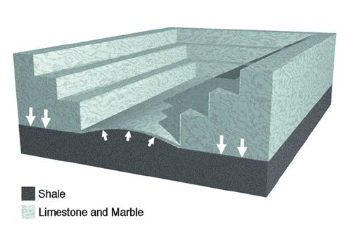 Figure 62: Buckling. The upward buckling of a deep, rock floor has been observed. A limestone quarry floor buckled upward in Yorkshire, England in 1887.39 The explanation is quite simple. Shale, which lay beneath the floor, consists of platelike particles that can slide over each other like playing cards in a deck. The weight of the quarrys walls squeezed shale toward the center of the quarry, increasing the pressure on the quarry floor. Once the slightest upward buckling began, the limestone floor weakened, allowing the shale to push up even more. In the flood cataclysm, the quarry was 10 miles deep, hundreds of miles wide, and 46,000 miles long. The high upward pressure on the exposed portion of the subterranean chamber floor was no longer balanced by the weight of the crust pressing down. Therefore, that portion of the chamber floor increasingly bulged upward, as happened in the quarry. Eventually, the hydroplates, still resting on a layer of water, began to slide downhill, away from the rapidly rising bulge. This removed even more weight from the chamber floor, accelerating its upward bulging. Today, the upbuckled region is the globe-encircling Mid-Oceanic Ridge. |
|
|
|
|
Logged
|
Joh 9:4 I must work the works of him that sent me, while it is day: the night cometh, when no man can work.
|
|
|
|
Soldier4Christ
|
|
« Reply #96 on: April 07, 2006, 07:12:59 AM » |
|
 Mechanical and civil engineers call this phenomenon the buckling of a plate on an elastic foundation.40 I have often demonstrated this to audiences by placing long bricks on top of a foam mattress compressed in a rigid box. Then I slowly remove the bricks from the foam mattress, beginning at the center and moving outward. When enough bricks are removed, the mattress suddenly springs upward, raising the remaining bricks. If these bricks were on a frictionless surface, they would slide downhill, just as continents (hydroplates) did during the continental-drift phase. As mountains buckled up, the remaining water under the plate tended to fill large voids. Some pooled water should still remain in cracked and contorted layers of rock. [See Figures 63 and 64.] This would partially explain the reduced mass beneath mountains that gravity measurements have shown for over a century.47 PREDICTION 1: Beneath major mountains are large volumes of pooled salt water.48 (Recent discoveries support this prediction, first made in 1980. Salt water appears to be about 10 miles below the Tibetan Plateau, which is bounded on the south by the largest mountain range on earth.)49 PREDICTION 2: Salty water will be found within cracks in granite, 5-10 miles below the earths surface (where surface water should not be able to penetrate). |
|
|
|
|
Logged
|
Joh 9:4 I must work the works of him that sent me, while it is day: the night cometh, when no man can work.
|
|
|
|
Soldier4Christ
|
|
« Reply #97 on: April 07, 2006, 07:14:42 AM » |
|
Friction at the base of skidding hydroplates generated immense heat, enough to melt rock, produce huge volumes of magma, and begin earths volcanic activity. Crushing produced similar effects, as broken and extremely compressed blocks and particles slid past each other. The deeper the sliding, the greater the pressure pushing the sliding surfaces together, and the greater the frictional heat generated. In some regions, high temperatures and extreme pressures from the compression event formed metamorphic rock, such as marble and diamonds. Where heat was most intense, rock melted. High-pressure magma squirted up through cracks between broken blocks. Sometimes magma escaped to the earths surface, producing volcanic activity and floods of lava outpourings (called flood basalts) as seen on the Columbia and Deccan Plateaus. Other magma collected under the earths surface in pockets, now called magma chambers. When magma escapes from these chambers, volcanoes erupt. The heat remaining today is called geothermal heat. (Sources of even greater amounts of magma will be explained in the next chapter.) Some subterranean water also flowed up into cracks in the crushed granite. This explains the concentrated salt water discovered in cracks deep under Russia and Germany. (Recall that surface water cannot penetrate down to those depths. This alone implies that subsurface water was its source.) Now we can understand why the waters salt concentration in these cracks was about twice that of seawater. By mixing the salty, subterranean water that escaped during the flood with an approximately equal volume of preflood surface water (which had little dissolved salt), the salt concentration of our present oceans would be achieved. As the Mid-Atlantic Ridge and Atlantic floor rose, mass had to shift within the earth toward the Atlantic. Subsidence occurred on the opposite side of the earth, especially in the western Pacific where granite plates buckled downward, forming trenches. [For details and evidence, see The Origin of Oceanic Trenches on pages 136155.] Surrounding the Pacific is the ring of fire, containing the best-known concentration of volcanic activity on earth. Within the ring of fire, hidden on the floor of the Pacific, are vast, thick lava flows and tens of thousands of ancient volcanoes. Frictional heating caused by high-pressure movements under the Pacific floor generated these lava outpourings that covered the hydroplate. Therefore, the western Pacific floor is littered with volcanic cones composed of minerals typically found in granite and basalt. Continental crust has been discovered under the Pacific floor. [See Endnote 11 on page 150, and the prediction on page 145.] Recovery Phase. Where did the water go? When the compression event began on a particular hydroplate, the plate crushed, thickened, buckled, and rose out of the water.50 As it did, the flood waters receded. 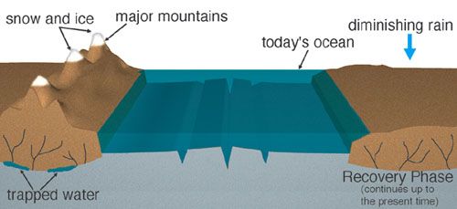 Figure 63: Recovery Phase of the Flood. |
|
|
|
|
Logged
|
Joh 9:4 I must work the works of him that sent me, while it is day: the night cometh, when no man can work.
|
|
|
|
Soldier4Christ
|
|
« Reply #98 on: April 07, 2006, 07:16:37 AM » |
|
Simultaneously, the upward-surging, subterranean water was choked off as the plates settled onto the subterranean chamber floor. With the water source shut off, the deep, newly-opened basins between the continents became reservoirs into which the flood waters returned. As you will recall, the floors of these deep reservoirs were initially part of the basalt floor of the subterranean chamber, about 10 miles below the earths surface. Consequently, sea level soon after the flood was several miles lower than it is today. This provided land bridges between continents, facilitating animal and human migration for perhaps several centuries. Sediments, mixed with organic matter and its bacteria, were swept with draining flood waters onto the new ocean floors. There, the bacteria fed on the organic matter and produced methane. Since then, much of this methane combined with cold, deep ocean waters to become vast amounts of methane hydrates along coastlines. Flood waters draining down the steep continental slopes eroded deep channels, especially downstream of drainage channels which are now major rivers. Today, we call these deep channels submarine canyons. After the flood, hydroplates rested on portions of the former chamber floor, and oceans covered most other portions. Because the thickened hydroplates applied greater pressure to the floor than did the water, the hydroplates slowly sank into the chamber floor over the centuries, causing the deep ocean floor to rise. (Imagine covering half of a waterbed with a cloth and the other half with a thick metal plate. The sinking metal plate will lift the cloth.) As sea level rose in the centuries after the flood, animals were forced to higher ground and were sometimes isolated on islands far from present continental boundaries. Classic examples of this are finches and other animals Charles Darwin found on the Galapagos Islands, 650 miles off the coast of Ecuador. Today, those islands are the only visible remains of a submerged South American peninsula. Darwin believed the finches were blown there during a giant storm. Even if Darwins unlikely storm happened, both a male and female finch, rugged enough to survive the traumatic trip, must have ended up on each island. The more sediments continents carried and the thicker continents grew during the compression event, the deeper they sank. This also depressed the Moho. Newly formed mountains sank even more, slowly depressing the Moho beneath them to 2030 miles below the earths surface. [See Figure 64.] The Moho and mantle under the ocean floor rose along with the ocean floor. This is why continental material is so different from oceanic material and why the Moho is so deep beneath mountains and yet so shallow beneath the ocean floor. 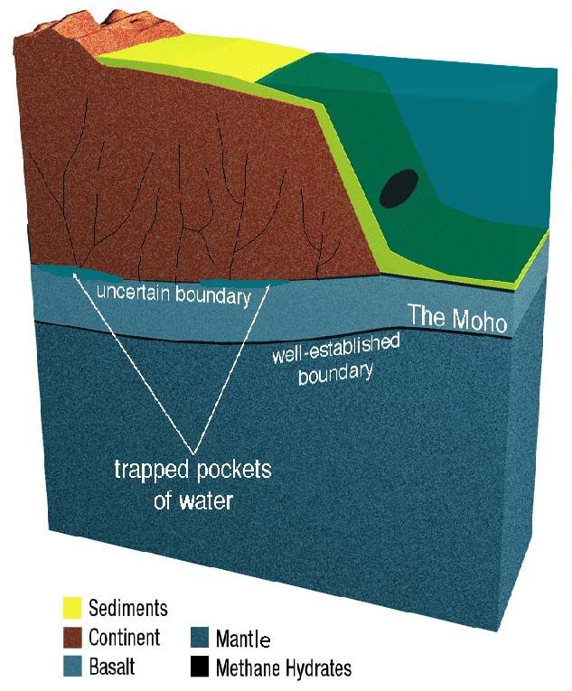 Figure 64: Typical Cross Section of Todays Continents and Oceans. Notice the relative depths of the Moho. It is deepest under major mountains and shallowest under the ocean floor. Although some boundaries are uncertain, most of these general characteristics are well established. Notice also that large pockets of water may be under major mountains. |
|
|
|
|
Logged
|
Joh 9:4 I must work the works of him that sent me, while it is day: the night cometh, when no man can work.
|
|
|
|
Soldier4Christ
|
|
« Reply #99 on: April 07, 2006, 07:16:57 AM » |
|
Many other things were far from equilibrium after the continental-drift phase. Over the centuries, the new mountain ranges and thickened continental plates settled slowly toward their equilibrium depthjust as a persons body sinks into a waterbed. Sinking mountains increased the pressure under the crust on both sides of mountain ranges, so weaker portions of the overlying crust fractured and rose, forming plateaus. In other words, as continents and mountains sank, plateaus rose. This explains the otherwise strange aspects of plateaus noted by George Kennedy on page 107.
It also explains why plateaus are adjacent to major mountain ranges. For example, the Tibetan Plateau, the largest in the world, is next to the most massive mountain range in the worldthe Himalayas. The Tibetan Plateau covers 750,000 square miles and rose to an elevation of about 3 miles. The Colorado Plateau, next to the Rocky Mountains, and the Columbia Plateau, next to the Cascade Mountains, are other dramatic examples.
Earth Roll. The sudden formation of major mountains altered the spinning earths balance,53 causing the earth to slowly roll about 35°45°. The preflood North Pole moved to what is now central Asia.54 (The shift produced a 6° precession of the earths axis that Dodwell discovered from studying almost 100 ancient astronomical measurements made over the last 4,000 years.) This is why coal,11 dinosaur fossils,55 and other temperate fossils56 are found near todays South Pole. Many researchers have also discovered vast dinosaur and mammoth remains inside the Arctic Circle. All were at temperate latitudes before the flood.
The direction and magnitude of the roll are also shown by animals and plants that today live at specific temperate latitudes but whose fossils are found inside the Arctic Circle. Remains of a horse, bear, beaver, badger, shrew, wolverine, rabbit, and considerable temperate vegetation are found on Canadas Ellesmere Island, inside the Arctic Circle. Such animals and plants today require temperatures about 27°F warmer in the winter and 18°F warmer in the summer.57 Also found are remains of large lizards, constrictor snakes, tortoises, alligators, tapirs, and flying lemursnow found only in Southeast Asia.58 Isotopic studies of the cellulose in redwood trees on Axel Heiberg Island, just west of Ellesmere Island, show that they grew in a climate similar to that of todays coastal forests of Oregon (35° farther south in latitude).59
Ellesmere Island and Axel Heiberg Island have the largest known contrast between current temperatures and inferred ancient temperatures based on fossils. Both islands straddle 85°W longitude. Therefore, regions near this longitude experienced large northward shifts following the flood. The preflood North Pole rolled south near 95°E longitude while the region presently occupied by todays North Pole rolled north near 85°W longitude. Also implied is a roll of at least 35°. Physics53 and geology54 give a similar picture.
An ancient historical record tells of a catastrophic flood and an apparent earth roll. Charles Berlitz reports that early Jesuit missionaries in China located a 4,320-volume work compiled by Imperial Edict and containing all knowledge. It states,
The Earth was shaken to its foundations. The sky sank lower toward the north. The sun, moon, and stars changed their motions. The Earth fell to pieces and the waters in its bosom rushed upward with violence and overflowed the Earth. Man had rebelled against the high gods and the system of the Universe was in disorder. 60
Endnote 53 explains why the Asian sky began sinking toward the north immediately after the flood.
Canyons. Drainage of the waters that covered the earth left every continental basin filled to the brim with water. Some of these postflood lakes lost more water by evaporation and seepage than they gained by rainfall and drainage from higher elevations. Consequently, they shrank over the centuries. A well-known example was former Lake Bonneville, part of which is now the Great Salt Lake.
Through rainfall and drainage from higher terrain, other lakes gained more water than they lost. Thus, water overflowed each lakes rim at the lowest point on the rim. The resulting erosion at that point on the rim allowed more water to flow over it. This eroded the cut in the rim even deeper and caused much more water to cut it faster. Therefore, the downcutting accelerated catastrophically. Eventually, the entire lake dumped through a deep slit which we today call a canyon. These waters spilled into the next lower basin, causing it to breach its rim and create another canyon. It was like falling dominoes. The most famous canyon of all, the Grand Canyon, formed primarily by the dumping of what we will call Grand Lake. It occupied the southeast quarter of Utah, parts of northeastern Arizona, as well as small parts of Colorado and New Mexico. [See the map on page 130.] Grand Lake, standing at an elevation of 5,700 feet above todays sea level, quickly eroded its natural dam 22 miles southwest of what is now Page, Arizona. In doing so, the western boundary of former Hopi Lake (elevation 5,950 feet) was eroded, releasing waters that occupied the present valley of the Little Colorado River. In only a few weeks, more water spilled over northern Arizona than is in all five Great Lakes combined.61
|
|
|
|
|
Logged
|
Joh 9:4 I must work the works of him that sent me, while it is day: the night cometh, when no man can work.
|
|
|
|
Soldier4Christ
|
|
« Reply #100 on: April 07, 2006, 07:19:10 AM » |
|
A Picture with a Story
Here at the Black Canyon of the Gunnison in Colorado, rock cliffs are exposed for up to 2,700 feet above the Gunnison River. Their marble-cake appearance comes from melted rock, primarily quartz, that was forced up through cracks in the darker rock.51 To appreciate the size of this cliff, notice the trees, 10 15 feet tall, at the top of the cliff.
Now, lets put aside all prior opinions and ask, What must happen to cause this marble-cake pattern? First, deep magma must be present or be produced.
(Figure 65 purposefully left out)
Second, the black rock must be fractured. This obviously takes gigantic forces acting over a large area, but the forces must be of a special kind. A tensile (stretching) force would produce one or at most a few evenly spaced cracks. At the instant of breakage, each broken piece would scatter. (Try breaking something by pulling on it. Upon breaking, the two pieces will fly apart.) This leaves us with only one viable type of force compression.52
If compressive forces acted equally in all directions, no breaks would occur. For example, deep sea creatures, living under high compressive pressure (inside and out), are not crushed. Also not crushed are many delicate pieces of pottery and other objects found in sunken vessels on the ocean floor.
If compressive forces acted slowly but were almost evenly balanced, slight but slow movements would occur at the atomic level, a phenomenon called creep. The rock would slowly flow like putty, until the forces balanced.
Some channels (or cracks) are wider than others. Normally, the largest channels provide the least resistance to the flow, and all the magma from below should have spilled out through them. (Pump a liquid into a closed container until it cracks. You will see only one or at most a few major cracks, not many little cracks.) If the magma had been contained in a chamber below, just waiting for a crack to appear, the first crack should release all the magma, unless it solidified on its way up through the colder rock. But if all cracks occurred at once, then magma would fill most cracks. All of this leaves us with one conclusion for how the fractures occurredrapid crushing.
Next, magma must rapidly squirt up through the cracks in the black rock. If it happened slowly, or even at the rate a river flows, the front edge of the upward flowing magma would solidify (freeze), stopping the flow. If water is dissolved in any molten rock, its melting or freezing temperature is lowered considerably. Therefore, liquid quartz with dissolved water could better survive the cold, upward journey.
Each individual channel (or vein) at the Black Canyon has a fairly uniform thickness. This reveals that the liquids pressure exceeded the rocks pressure by nearly the same amount all along the channel. Again, this would not happen if the flow were slow or its consistency like cold tar.
This marble-cake appearance is exposed for at least 50 miles along the Gunnison River, so the compressive force must have been about the same over at least those 50 miles. Magma, if it came from one spot below, would tend to escape through the shortest cracks leading to the surface. Instead, magma has filled cracks over a 50 mile range. Consequently, the magma source and any water was probably spread over a large area directly below.
Because similar structures are seen where other deep basement rocks are exposed, these gigantic forces either cropped up many times at different places or this happened once on a continental or global scale. The parsimony criterion (looking for the simplest explanation) leads us to favor one big event. We will call this the compression event.
(Figure 66 purposefully left out)
Figure 66: Inner Gorge of the Grand Canyon. The same marble-cake pattern exists in the inner gorge of the Grand Canyon, but with less color contrast than at the Black Canyon of the Gunnison.
|
|
|
|
|
Logged
|
Joh 9:4 I must work the works of him that sent me, while it is day: the night cometh, when no man can work.
|
|
|
|
Soldier4Christ
|
|
« Reply #101 on: April 07, 2006, 07:20:33 AM » |
|
We can conclude that this crustal rock was rapidly crushed over a wide area. Magma, and probably dissolved water, spread out below, were then quickly injected up through the cracks.
In studying this effectan immense layer of marble-cake rockwe tried to deduce its cause. One can easily err when reasoning from effect back to cause. Another approach, that of reasoning from cause to effect, unfortunately requires starting assumptions. We began this on page 110 with two assumptions and then looked at their logical consequences. When cause-to-effect reasoning is consistent with effect-to-cause reasoning, as it is here, confidence in our conclusion increases greatly.
Sediments from the Grand Canyon were spread a hundred or so miles on either side of the present Colorado River, downstream from the Canyon. Today, these sediments, composed of rounded boulders mixed with clay, are exposed where streams have cut channels 100200 feet deep. The rounded boulders show that they were transported by high-velocity water. The unsorted mixture of clay and boulders indicate that the turbulent water suddenly slowed, depositing the unsorted mixture.
With thousands of large, high lakes after the flood, and a lowered sea level, many other canyons were carved. Some are now covered by the raised ocean. It appears that (1) the Mediterranean Lake dumped into the lowered Atlantic Ocean and carved a canyon at the Strait of Gibraltar, (2) Lake California filling the Great Central Valley of California carved a canyon (now largely filled with sediments) under what is now the Golden Gate Bridge in San Francisco, and (3) the Mediterranean Sea or the Black Sea carved out the Bosporus and Dardanelles.
PREDICTION 3: The crystalline rock under Gibraltar, the Bosporus and Dardanelles, and the Golden Gate bridge will be found to be eroded into a V-shaped notch. (This prediction concerning the Bosporus and Dardanelles, first published in 1995, was confirmed in 1998.)62
PREDICTION 4: The Global Positioning System (GPS) measures plate velocities with ever increasing accuracy as data accumulates and equipment improves. Because the earths crust is shifting toward equilibrium, todays plate velocities will be found to be very gradually decreasing.
|
|
|
|
|
Logged
|
Joh 9:4 I must work the works of him that sent me, while it is day: the night cometh, when no man can work.
|
|
|
|
Soldier4Christ
|
|
« Reply #102 on: April 07, 2006, 07:21:07 AM » |
|
Earthquakes. The flood produced great mass imbalances on earth, and this causes earthquakes. Continents sank into the mantle and lifted ocean floors. These movements are slowly approaching their equilibrium positions. Shifting material63 throughout the earth is the root cause of earthquakes and slowly shifting continents. Both phenomena have been misinterpreted as supporting plate tectonics. (The following chapter explains this in greater detail.)
These powerful forces have different consequences at different depths. Some minerals suddenly rearrange their atoms into denser packing arrangements when the temperature and pressure rise above certain thresholds. This produces chains of microscopic implosions a few hundred miles below the earths surface.64 Because the flood occurred only about 5,000 years ago, temperatures are not uniformly hot at these depths.
Shallow earthquakes involve a different phenomenon.65 Trapped, subterranean water, unable to escape during the flood, slowly seeps up through cracks and faults formed during the crushing of the compression event. (Seismographs on the Pacific Ocean floor have measured tremors with these characteristics.)66 The higher this water migrates through a crack, the more its pressure exceeds that in the walls of the crack trying to contain it. Consequently, the crack spreads and lengthens. (So before an earthquake, the ground often bulges slightly, water levels sometimes change in wells, and geyser eruptions may become more irregular.) Simultaneously, stresses build up in the crust, again driven ultimately by gravity and mass imbalances at the end of the flood. Once compressive stresses have risen enough, the cracks have grown enough, and the frictional locking of cracked surfaces has diminished enough, sudden movement occurs. Water acts as a lubricant. (Therefore, frictional heat is not found along the San Andreas Fault.) Sliding friction instantaneously heats the water, converts it to steam at an even higher pressure, and initiates a runaway process called a shallow earthquake. [For more details, see The Origin of Oceanic Trenches on pages 136155.]
Ice Age. As mentioned on page 105, an ice age requires cold continents and warm oceans. Some currents of water exiting the rupture were hot. Also, sliding hydroplates generated frictional heat as did movements within the earth resulting from the rising Atlantic and subsiding Pacific Ocean. Floods of lava spilling out, especially onto the Pacific floor, became vast reservoirs of heat that maintained elevated temperatures in certain ocean regions for centuriesthe ultimate and first El Niño.67 Warm oceans produced high evaporation rates and heavy cloud cover.
Temperatures drop as elevation increases. For example, for every mile one climbs up a mountain, the air becomes about 28°F colder.68 Therefore, after the flood, the elevated continents were colder than today. Conversely, lowered sea levels meant warmer oceans. Also, volcanic debris in the air and heavy cloud cover shielded the earths surface from much of the Suns rays.
At higher latitudes and elevations, such as the newly elevated and extremely high mountains, this combination of high precipitation and low temperatures produced very heavy snow fallsperhaps 100 times those of today. Large temperature differences between the cold land and warm oceans generated high winds that rapidly transported moist air up onto the elevated, cool continents where heavy snowfall occurred, especially over glaciated areas. As snow depths increased, periodic and rapid movements of the glaciers occurred in avalanche fashion. During summer months, rain caused some glaciers to partially melt and retreat, marking the end of that years ice age.
|
|
|
|
|
Logged
|
Joh 9:4 I must work the works of him that sent me, while it is day: the night cometh, when no man can work.
|
|
|
|
Soldier4Christ
|
|
« Reply #103 on: April 07, 2006, 07:22:27 AM » |
|
(Figure 67 purposefully left out)
Figure 67: Kashmir Basin Today. Consider whether this bowl-shaped region rose several miles in a few hours, carrying in its basin flood waters and fish. If so, the potential existed for Lake Kashmir to later overflow its rim and quickly carve a huge canyon, leaving the Jhelum River as a remnant of that event.
While legends and geological facts are consistent with this scenario, two questions remain. What could quickly lift the Himalayas, the most massive mountain range on earth? Can conventional geology explain these geological facts?
This chapter has answered the first question. Details below address the second question. The Grand Canyon and numerous other canyons are prime exhibits showing they too are best explained by a similar catastrophic event. Wouldnt it be nice if eye witnesses could confirm this event? Consider the legend described below.
Kashmir, a disputed territory high on the borders of northern India and Pakistan, has an interesting geological and cultural history. Half of Kashmirs seven million people live in an oval valley, the size of Delaware, more than one mile above sea level. That valley is surrounded high mountains containing fossils of sea life. Rain falling into this bowl-shaped region eventually enters the Jhelum River which flows out between almost vertical canyon walls, 7,000 feet high, in a channel cut through the rim of the bowl.
Many Hindu legends are written in The Nilamata Purana. Verses 138180 tell of a vast, ancient lake that once filled this valley and contained a demonic sea monster who ate people. Hindu gods decided to help the people by cutting an outlet for the lakes waters through the surrounding mountains. Once the lake drained, the hero killed the immobilized monster. Since then, the lakes bottom has been a fertile home for the people of Kashmir, most of whom know this story.
Geologists now realize that the valley once held a giant lake! The thinly layered strata of clay, limestone, and shale containing microscopic sea shells, show that the valley was once under water. Was this just a lucky guess by the ancient writers of The Nilamata Purana myth? Did they understand geology and create a story to fit the evidence? They would have needed a microscope to see much of the evidence. Perhaps some truth lies behind this myth.
Geologists claim that the entire region, including the bordering Himalayan Mountains, rose during the past 15,000,000 years. If so, the fossils on top should have eroded, because erosion occurs rapidly in mountainous terrain subject to many freezing-thawing cycles.
Why did this region rise? How could a lakeand fishaccumulate in a high, remote, draining valley? Even if the valleys outlet had not yet formed, why would a large lake form at that cold, high elevation? Snow or glaciers might accumulate but rarely a large lake. At high elevations, evaporation rates are generally faster and precipitation rates slower. (Today, the worlds largest lake a mile or higher above sea level is Lake Titicaca,69 astride the border of Bolivia and Peru. Kashmirs ancient lake was probably larger.) Because those events supposedly happened millions of years before humans evolved, why does a human account, historical or mythical, speak of the lake and the cutting of the canyon?
The hydroplate theory unifies, clarifies, and provides additional details to this cultural and geological picture. During the compression event, as moving continents suddenly crushed, thickened, and buckled to varying degrees, the Himalayan Mountains rose. As the waters drained off the continents, every bowl-shaped basin became a lake, regardless of elevation. Kashmirs lake was immediately full and could have held fish. Later, after people migrated to the region, the lake breached part of its boundary and quickly cut its canyon. Today, the Jhelum River is a remnant of that lake. Undoubtedly, other canyons of the world, including the Grand Canyon, formed in a similar way.
|
|
|
|
|
Logged
|
Joh 9:4 I must work the works of him that sent me, while it is day: the night cometh, when no man can work.
|
|
|
|
Soldier4Christ
|
|
« Reply #104 on: April 07, 2006, 07:24:45 AM » |
|
Whats Ahead Twenty-four mysteries related to the earth have been briefly explained, answered, and interrelated. Each of the next six chapters will examine one of the 24 topics in detail: oceanic trenches, layered strata and fossils, limestone, frozen mammoths, comets, and finally asteroids and meteoroids. Each chapter will contrast the hydroplate theory with all leading explanations and will add a surprising new dimension to the hydroplate theory and the floods destructiveness. As you read these chapters, keep in mind that all the theorys details and events were consequences of one assumption (page 110) and the laws of physics. 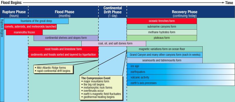 Figure 68: Sequence of Events. Although the floods consequences, displayed above, are correctly sequenced, each phase has a different time scale. Each consequence shown in red is the subject of a subsequent chapter. (Notice that the mammoths were frozen during the rupture phase, but the ice age began during the recovery phase and is diminishing today.) |
|
|
|
|
Logged
|
Joh 9:4 I must work the works of him that sent me, while it is day: the night cometh, when no man can work.
|
|
|
|


